
Wonder Maps by Bright Ideas Press
Download or CD $49.95 (Also requires Adobe Reader 9.1 to be installed on the computer) Readers of The Old SchoolHouse Magazine can receive 20% with the coupon code found in Bright Ideas Press' ad in the current issue
Wonder Maps is a computer program featuring historical and contemporary worldwide maps which can be customized by the user. This is a very complete collection of maps, encompassing the world and history. Biblical History, Post Biblical History, all of the continents, and the United States are included.
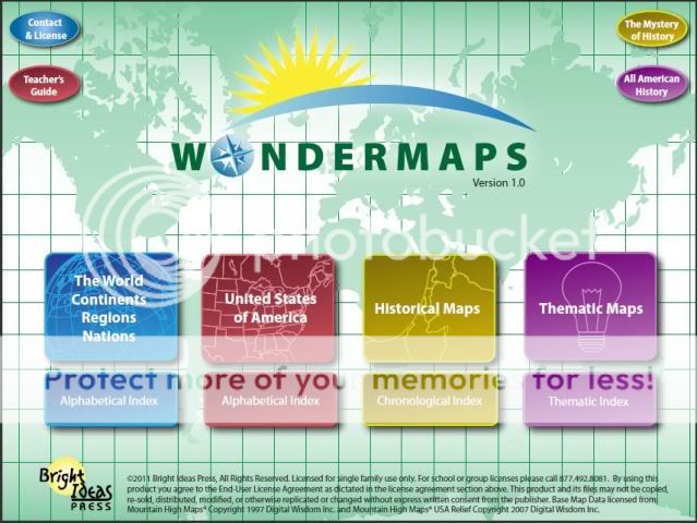
The program has maps arranged in four groups: The World, United States, Historical, and Thematic.There is an individual index for each of these groups.
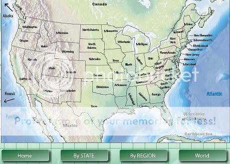 |
| Sample picture of US map |
From this page you can select individual state maps or regional maps of several states.
The World maps feature continents, regions, and nations, however for many continents there are only maps of regions, not individual countries. Historical Maps are broken down into the following time periods: The Ancients; The Middle Ages; Renaissance, Reformation and Growth of Nations; and Revolutions to the Rising Times.
All of the maps for The Mystery of History and All American History curriculums are included in Wonder Maps and accessed from a button on the main screen. The user is then directed to choose the particular book they are using.
Wonder Maps is very easy to navigate. The opening screen has a button for each of the four map category and their corresponding index. Using the index to locate a specific map is easy, just find the map you want and click on its title and it automatically opens.
Upon opening the map you will have a bookmark on the left side of the screen (less than ¼ of the screen) and the remainder of the screen is your map. From there you can click on one of the titles in the bookmark or a label on the map. From there you can get a more detailed map of an area or country. There is also an option to see thumbnail maps in the chosen category. Clicking on a map label will take you to a more detailed map.

The individual maps feature the option to add or remove many features. The options include color or black and white; names and locations of countries or states, capitals and cities; and rivers and streams. Some maps also include terrain features. Each of these features can be added or removed by clicking the “eye” icon on or off.
When looking at maps of the continents your options are varied. For some continents you can choose the individual country, some other continents only have the option of regional maps showing several countries. For the United States you can choose maps of the individual states or regions, which encompass several states. There US territories are also featured on a large world map and numbered according to a key. For many countries there is not an individual map. All of these maps can be customized in the ways mentioned above.
Maps can be printed with various features included or removed depending on the goal of the study.
In addition Wonder Maps includes a Teachers Guide which has a 1 page quick start guide, a tutorial video, user manual, two downloadable MP3’s and resource ideas for using Wonder Maps, integrating geography and history, and making the study of geography exciting.
How we used Wonder Maps
So far we have looked at different maps and investigated all the neat features that are included. While doing this we have talked about many geographic features and locations.
I particularly like the ability to take off place names, yet leave markings for their locations. This is great as we continue to study all of the individual states in the US. It will allow for having my children label cities and places in the states and not have to figure out exact locations. This will be great for my oldest especially in other history map assignments.
While these features are nice and make it so easy to learn about a region, I have been disappointed in the quality of the actual maps. As an example, the state of Minnesota is included in several regional maps of the US. One of these maps has no indication of the beginning of the Mississippi river, it looks like it forms from a junction with the Minnesota river. But another map indicates the Mississippi beginning where it actually does in Northern Minnesota and receiving the waters of the Minnesota river south of St Paul which is correct.
I also looked at the Civil War maps in preparation to study this time period with my children. One map is color coded to show which states stayed with the Union and which went with the Confederacy. However, in history there were also several states which were border states and thus had divided loyalties. These border states are not recognized as such. The map would be greatly improved by showing this as it is important to the whole cause and situation.
Additionally several of the Bible maps are inaccurate according to the Biblical text and historical resources from closer to the time period.
Due to these discrepancies, it is hard to judge the quality and reliability of the maps themselves. However, several crewmates have said Bright Ideas Press is very responsive to notes about discrepancies or errors nin the map.
My 7 year old son thinks Wonder Maps is “Just cool”. He has spent a lot of time playing with the maps and checking out all the different features he can put onto a map. It has also inspired him to learn more about some of the geographic features he has seen on the map. He is capable of studying the maps and using all their features himself.
Read what other crew members had to say at the crew blog.

Disclaimer: I received a free copy to use and help me write this review. I have not been compensated in any other way and all views expressed here are solely my own.
No comments:
Post a Comment